
(A version of this post originally appeared as part of the December 8 launch of Arctic Deeply, a now sadly defunct independent digital media project dedicated to northern issues.)
Ideas about Arctic exploration and science often involve images of rugged explorers plying the sea ice in 19th-century wooden ships or in cushy, multimillion-dollar 21st-century icebreakers. But since the 1970s, a large number of advances in Arctic science have come from satellites orbiting hundreds of kilometers above the Earth. Tough terrain and environmental conditions make the Earth’s polar regions challenging and expensive to access. Satellites have amassed a wealth of information about the polar regions that would have otherwise been extremely difficult to obtain.
Satellite images have captured swift changes in the Arctic’s natural environment, from retreating glaciers to forest fires in Alaska. Some of the most widely circulated photographs of the Arctic have been taken from space. For example, images of the Arctic ice cap have driven home the dramatic reduction in summer sea ice between 1979 – the first year of available satellite records – and the present.
Satellites: Tools for studying human activity from space
Satellite imagery of the Earth can also be used to analyze human activities in the Arctic. When cities, roads, ships and gas flares illuminate the night sky, these lights are captured with a high degree of accuracy by one of the newest satellites in operation – the Suomi National Polar Partnership (NPP).
Launched in October 2011 by NASA and the National Oceanic and Atmospheric Administration (NOAA), Suomi NPP scans the Earth from 65°S to 75°N every night using its dedicated day-night band. It therefore scans the planet from just above the northernmost tip of Antarctica to the outermost edges of the inhabited Arctic. The resolution of these images is fairly low – each pixel in the image represents 750m (2,460ft) on the ground – but the satellite’s day-night band is so sensitive to low levels of light that it can detect the glow of a single street lamp.
This is important for observing the Arctic, which spends up to six months of the year in varying degrees of darkness. Since the Suomi NPP satellite’s day-night band is not dependent on solar illumination, it can transmit images of the Arctic throughout the winter, when other satellites fail to capture much at all.
This new source of satellite imagery has helped to save lives in the harsh Arctic winter. In February 2013, the National Weather Service’s Ice Desk used a direct feed of day-night band imagery to help guide F/V Kiska Sea, a crab-fishing vessel, out of treacherous waters in the Bering Sea, which became unexpectedly choked with sea ice, to guide it back to safety.
The benefits of night-light imagery in the Arctic
Day-night band imagery, which is also referred to as night light imagery, can also be used for monitoring maritime activities in the Arctic. As the ice cap shrinks, the Arctic Ocean is becoming increasingly accessible to marine traffic. In a paper published last year in the journal Remote Sensing, scientists used night light imagery to track a Russian nuclear icebreaker transiting the Northern Sea Route, the passage along the north coast of Russia that may one day link European and Asian markets if sea ice melt, infrastructure investment and certain market conditions persist.
Night light imagery can even be used to track movement on land in the Arctic, which increases significantly in winter. Once the annual freeze arrives, boggy and impassable tundra hardens into a surface that can be traversed. For two to three months of the year, frozen rivers are used as ice roads in places such as Alaska, Canada and Russia – as made famous on the television show “Ice Road Truckers.”Convoys of trucks travel the world’s longest heavy haul ice road, the Tibbitt to Contwoyto Winter Road in the Northwest Territories, from late January to late March every year to deliver supplies to the diamond mines that power the territory’s economy, and these can be seen at night by Suomi NPP.
Thanks to its improved resolution, Suomi NPP represents a leap forward from the previous satellite that captured night-light imagery, the Defense Meteorological Satellite Program. Furthermore, unlike with the previous satellite, all Suomi NPP data is free for anyone in the world to download, from national coast guards to nonprofit organizations to concerned citizens. This broad availability of data presents the opportunity to use night-light imagery to monitor activities in the Arctic and even spot illicit industrial activities – from illegal fishing to heavy industry – so long as the pursuits produce reasonably bright light.
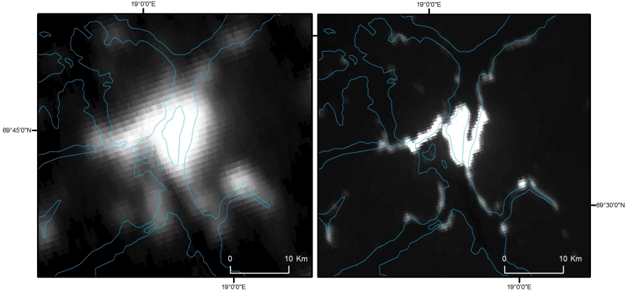
Issues with Suomi-NPP
Suomi NPP isn’t a perfect all-seeing eye, however. During twilight conditions, which are more prevalent at the poles than in equatorial regions, data can be affected by a problem called stray light, which obscures the clarity and accuracy of the images (as seen in Figure 2). Still, as human activity in the Arctic increases at sea and on land, Suomi NPP and its planned successor, the Joint Polar Satellite System due to launch in early 2017, promise to bolster the safety of people in the North and enhance our understanding of the patterns and dynamics of development in the last frontier.

