With Shell receiving conditional approval to drill in the Chukchi Sea in offshore Alaska, the phrase “continental shelf” has come up a lot lately. The term also appears whenever territorial disputes in the Arctic make the news. But maps such as this one published by the Economist don’t exactly clarify what the continental shelf is, nor how its geography and terrain are literally at the bottom of so many disputes in the Arctic and indeed worldwide. So how can we better depict this underwater terrain, especially up north?
The International Bathymetric Chart of the Arctic Ocean (IBCAO) is the gold standard when it comes to cartographically displaying the texture of the continental shelf in the Arctic. The map has a resolution of 500 meters and much of the data comes from state-of-the-art multibeam surveys. You can read more about how the map was made in a paper published in Geophysical Research Letters in 2012.
However, what the map doesn’t display is geopolitical data. It’s interesting, for instance, to overlay the outlines of countries’ exclusive economic zones (EEZs) onto the bathymetric data. But before we do that, let’s look a bit more at the shelf’s topography.
The geological shelf

Using the ETOPO1 1 Arc-Minute Global Relief Model available from the National Oceanic and Atmospheric Administration, I made a simple map in ArcGIS displayed at the top of this post of the continental shelves in the Arctic.* While the continental shelf exists in reality as an underwater extension of a continent, it’s important to remember that even the idea of a continent is a social construct. If we were to redraw the world’s continents from an underwater, continental-shelf based perspective, we likely wouldn’t divide North America and Asia.
With this in mind, it becomes clear why it will be so hard to divvy up the continental shelf. Due to the presence of countries on top of the continental shelves, they will ultimately not be so much geologically as politically defined. Is the much-disputed Lomonosov Ridge, for instance, an extension of the Canadian, Russian, or Danish continental shelf? The fact that each country could claim it based on supposedly objective bathymetric evidence demonstrates the malleability of geology to political aims.
Yet divide the shelves they will, and that’s because sizable deposits of oil, gas, and other natural resources lie in wait. The continental shelves is where all Arctic offshore drilling will occur, with drilling looking something like this Gazprom diagram. As the U.S. Geological Survey stated in 2008, “The extensive Arctic continental shelves may constitute the geographically largest unexplored prospective area for petroleum remaining on Earth.” Their survey did not include the oil and gas resources that might lie in the seabed in the middle of the Arctic Ocean where the continental shelves drop off. By the time technology reaches a state where deepwater drilling in the Central Arctic Ocean becomes possible, humanity will hopefully have transitioned away from relying on fossil fuels.
Viewed in 3D, the nearly “landlocked” nature of the Arctic Ocean becomes evident, too. The Arctic Ocean is the world’s smallest, shallowest ocean. Its low average depth of ~1,000 meters is partly a result of the extension of many continental shelves, especially Russia’s, far into the ocean. The oil and gas exploration taking place on the shelf right now is therefore happening in relatively shallow water. Shell’s plans this summer on the Alaskan continental shelf entail drilling in water depths of about 42 meters. This is much shallower than deepwater drilling, which is typically characterized as occurring in depths of more than 150 meters. While Arctic offshore oil and gas drilling faces a number of environmental challenges, deepwater is not one of them at the moment.

A 3D perspective also illustrates the degree to which Russia faces the north. Its major rivers, the Ob, Yenisey, and Lena, drain out to the Arctic Ocean. The image below reveals how the Ob River cuts a chasm into the tundra as it rushes north. In the Soviet era, some politicians and scientists sought to reverse the northward flow of the country’s three major rivers so that they would irrigate the deserts of Central Asia for agriculture instead of “wastefully” flowing into the Arctic Ocean. Now, as the country turns north again and looks out towards a warming ocean with new possibilities for shipping and natural resource extraction, many Russians may be glad that their rivers still flow to the “northern icy sea,” as the Arctic Ocean is called in Russian (северный ледовитый океан).

The legal shelf
The continental shelf is knee-deep in legalities, clauses, and commissions. Article 76 in the United Nations Convention on the Law of the Sea defines the continental shelf of a Coastal State as:
“the seabed and subsoil of the submarine areas that extend beyond its territorial sea throughout the natural prolongation of its land territory to the outer edge of the continental margin, or to a distance of 200 nautical miles from the baselines from which the breadth of the territorial sea is measured where the outer edge of the continental margin does not extend up to that distance.”
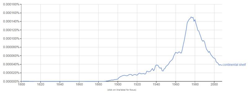
The treaty was adopted in 1982, riding the crest of an upswing in the usage of the phrase “continental shelf” in English language publications as evinced by this Google ngram.

It’s hard to materially grasp the notion of the continental shelf when it is defined in terms of nautical miles, baselines, and continental margins – terms unfamiliar to most laypeople, which is why maps that integrate geology and geopolitics are important. In the Arctic, the two are inseparable, after all. The territorial disputes there all hinge on each Arctic coastal state’s claims to their respective continental shelf. Once a claim is recognized, a country earns the exclusive right to explore and exploit its resources, both living and non-living.
Claims are submitted to the United Nations Commission on the Limits of the Continental Shelf (UN CLCS), which is composed of 21 mostly male engineers, geologists, hydrographers, and other scientists from around the world. Members are elected for five year terms, with the current term lasting from 2012-2017. All of the commission’s members have real jobs, meaning that the UN CLCS is a side gig for them. That may explain why the commission’s website hasn’t been updated since September 2013. This group makes recommendations on country’s submitted claims, but they are expressly apolitical and often will not consider data from disputed areas. As such, countries can opt to only submit data in undisputed areas, coordinate claims with neighboring countries, or even make a joint claim.
Once a country’s submitted geological information is deemed scientifically sound, it is up to neighboring states to mutually delimit their borders. The United Nations will not delimit any borders on the continental shelf. If the countries can’t agree between themselves, they can go to the International Court of Justice – as happened in 1993 between Denmark and Norway over the area between Greenland and Jan Mayen. Canadian law professor Michael Byers has written a book called International Law and the Arctic that goes into the various submission options in much more detail for readers who are interested (and the section on continental shelf claim submissions is freely available to read on Google Books, too).
The geopolitical shelf

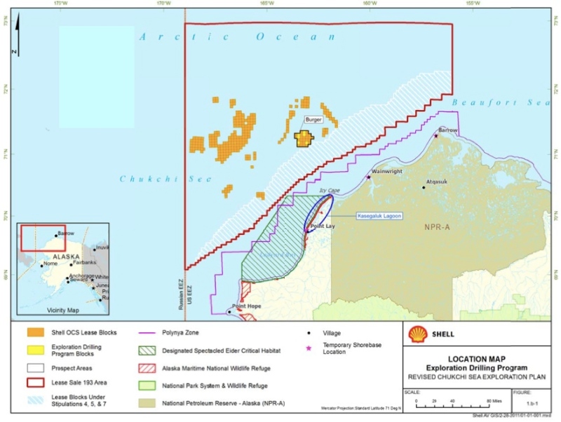
Now we can take a look at the bathymetric data with some geopolitical data overlaid. As the map above reveals, Russia has by far the largest continental shelf of any Arctic country. It’s no surprise that the country has moved the quickest of all the Arctic coastal states in exploiting its offshore oil and gas, for it simply has a much bigger amount of offshore territory to exploit. In Canada, by contrast, the country’s archipelago almost extends to the northernmost edge of the continental shelf. Delineations of the continental shelves and the respective EEZs also affect where current oil and gas exploration can take place. On the one hand, resolving territorial claims can be conducive to extraction since it removes gray areas from the map. Transnational corporations will simply not drill for oil in areas where the legal regime is unclear. On the other hand, corporations do have to be acutely aware of where EEZs lie so as not to wander into another country’s zone. In 2012, Shell’s leases in the Burger Prospect in the Chukchi Sea, issued by the U.S., stopped just before the boundary with the Russian EEZ. (This year’s exploration plans will take place a little bit farther west.)

A map of continental shelves doesn’t just hint at where future territorial claims and oil and gas exploration may take place. It also helps shed light on past movements of humans. For instance, Alaska and Chukotka, in eastern Russia, pretty much look like they lie on one extended sunken landmass, which some refer to as Beringia. This name evokes the migration that humans from Northeast Asia made across the Bering Strait to North America some 18,000 years ago. Back then, such political constructs of nations and continents didn’t exist. Instead, a grassy tundra covered the land for as far as the eye could see. Today, Beringia is an undersea relic of the Ice Age, with beluga whales and walruses swimming above the watery landscape once crossed by humans. Imagine how the geopolitics of the Arctic would differ today if the sea level was a few hundred feet lower and the continental shelves of the Arctic rose above the surface of the water.
Note
*After making these maps, I came across GEBCO’s higher-resolution 30-arc second model gridded bathymetric chart of the oceans, which I will use in future maps.


One comment
The continental shelf: geological, legal, or geopolitical?